
🚩🚩Stay Updated on Major Hurricane Ian with NWS NOAA Weather Radio & Real-Time Hurricane Warning App


GOES-East IR & GEOCOLOR Satellite Imagery (CIRA/NOAA)


NHC Marine Forecasts & Analysis

Saharan Dust Layer: GOES16 RGB Air Mass
Saharan Dust Layer is one of the main inhibitors of tropical systems. These particulates can block or effectively “choke” tropical systems from feeding off incoming solar radiation.

2022 Atlantic Hurricane Season Thus Far
| Name | Peak Strength | Active | Max Wind Speed | Landfall |
|---|---|---|---|---|
| Alex | Tropical Storm | 5-6 June | 70 mph | FL as PTC1 |
| Bonnie | Tropical Storm | 1-2 July | 50 mph | Nicaragua |
| Colin | Tropical Storm | 2-3 July | 40 mph | SC to NC |
| Danielle | CAT 1 Hurricane | 1-8 Sep | 90 mph | No |
| Earl | CAT 2 Hurricane | 2-10 Sep | 105 mph | No |
| Fiona | Tropical Storm | 60 mph | N/A | |
| Gaston | ||||
| Hermine | CAT 3 | |||
| Ian |
Data Courtesy of NHC as of September 15, 2022.
What is a Tropical Cyclone?

The National Hurricane Center defines a tropical cyclone as “A warm-core non-frontal synoptic-scale cyclone, originating over tropical or subtropical waters, with organized deep convection and a closed surface wind circulation about a well-defined center. Once formed, a tropical cyclone is maintained by the extraction of heat energy from the ocean at high temperature and heat export at the low temperatures of the upper troposphere. In this they differ from extratropical cyclones, which derive their energy from horizontal temperature contrasts in the atmosphere (baroclinic effects).”

Hurricanes are intense tropical cyclones that originate from tropical waves and detached frontal boundaries given the right circumstances. When a wave increases in amplitude, a tropical disturbance may continue to develop if this broad area of Low pressure remains isolated from frontal systems for 24 hours. As the Invest intensifies, environmental conditions will play a major factor on whether this tropical cyclone becomes a hurricane and which direction the system will trend.
Did You Know: Walt Disney World resort buildings are rated to withstand Major Hurricane-force wind gusts?
Atlantic Hurricane Season: When and Where
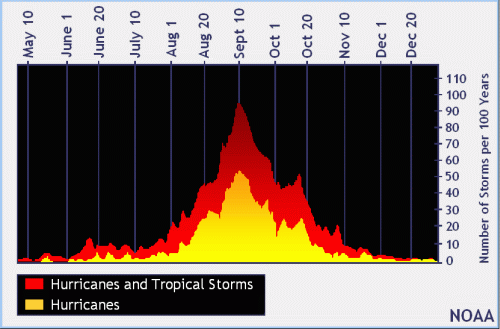
The Atlantic Basin Hurricane Season officially lasts from June 1st until November 30th. Historical Hurricane activity peaks between mid-August and the end of October with a spike in activity about September 10th.
A monthly pattern has emerged showing their likely areas of formation and prevailing tracks. Still Tropical Cyclones can deviate from these average trajectories and form in various regions across the Atlantic Basin.


Hurricanes do not need to make a direct Landfall to have lasting effects. Devastating storm surge and fast-moving rain bands have cost coastal communities billions of dollars without the area of circulation, also known as the Eye, ever coming ashore. It only take one Hurricane to make this season an Active Season for your community. Staying Weather Aware is pivotal during Hurricane Season.
