Follow @StormyStitch on Twitter for daily forecasts, nowcasting, and time-sensitive Weather Warnings in central Florida during Severe Weather. Warnings will not be updated on this webpage.
ACTIVE: Tornado & Severe Thunderstorm Watches


Today’s Current Convective Outlook with Composite Radar

| Current Day 2 Outlook | Current Day 3 Outlook | Current Days 4-8 Outlooks |
 |  |  |
Today’s SPC Storm Reports


What is Severe Weather?
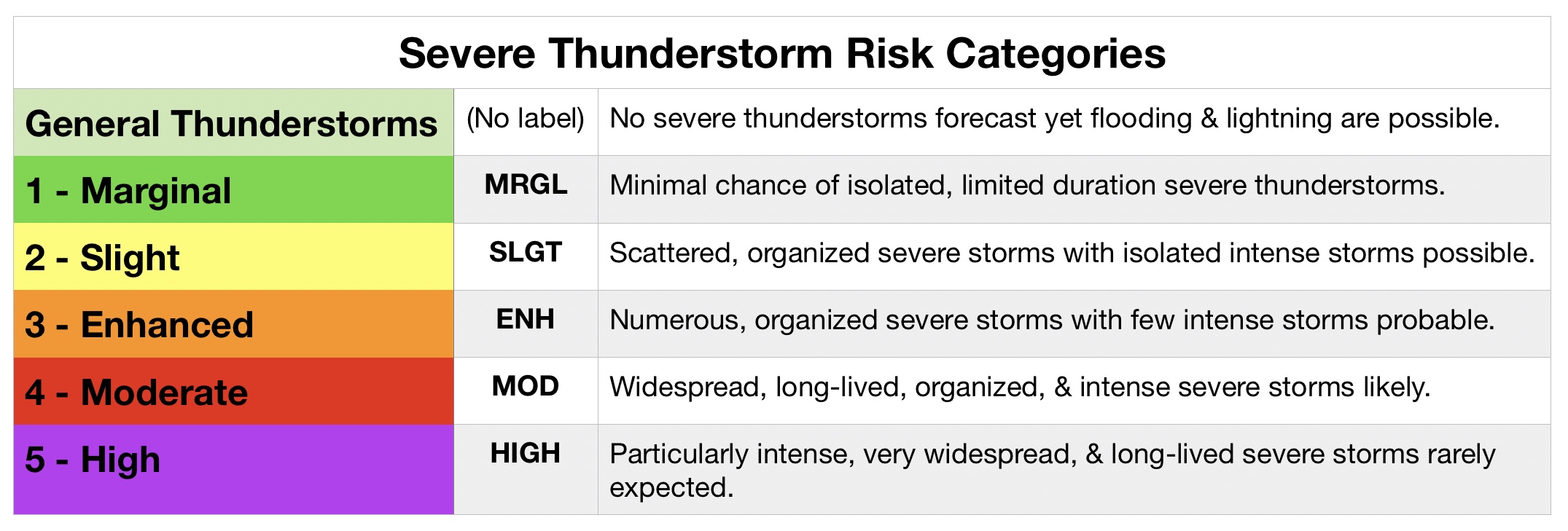
Severe weather occurs around the world and on every continent except Antarctica. In the United States, the National Weather Service defines a severe thunderstorm as any storm that produces one or more of the following: a tornado, damaging winds in excess of 58mph (50kts), and/or hail 1″ in diameter or larger (Storm Prediction Center).
A Watch Does NOT = Warning

While the Storm Prediction Center issues various advisories by the minute, Watches and Warnings are commonly misunderstood. During severe weather, the following types of Warnings, Watches, Advisories, and Statements may be issued:
- Severe Thunderstorm
- Tornado
- Flash Flood
- High Wind
A Watch may be outlined for a large area, typically spanning across portions of 1 or more states, for 2 to 8 hour time frame during which there is the potential for weather to exceed severe perimeters.
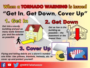
When there is imminent threat of severe conditions, a Warning will be issued due to an imminent threat within 1 hour for 1 county or more after the storm or organized system has been spotter confirmed or radar-indicated.
Remember a Watch is not equivalent to a Warning and does NOT guarantee you will see severe weather. This is time for you to prepare and not be scared. Talk with your loved ones about what you should do during a Severe Thunderstorm or Tornado Watch.
How are Tornadoes Rated?
In the United States, the Enhanced Fujita (EF) Tornado Intensity Scale is used to estimate each tornado’s maximum 3-second wind gusts based on its storm damage. The original Fujita Scale was developed by Dr. Fujita and his team. Their work has saved countless lives and laid the groundwork for meteorological research. The Enhanced Fujita Scale was implemented in the United States on January 1, 2007 as a set of wind estimates (not measurements) based on storm damage.

After a tornado has passed or in the days afterward, trained teams from local National Weather Service offices will be sent to identify and document storm debris. They are trained to determine whether the damage was caused by straight-line, microburst or macroburst, or tornadic winds.
Forecast Tools
COD Meteorology – Numerical Model Data
NWS Melbourne – Local Mesoscale Model
NWS Melbourne – Probabilistic QPF
NWS Central Florida MOS Forecasts
Storm Prediction Center Forecast Tools
Thank you to NOAA’s National Weather Service meteorologists, and dedicated staff members for keeping us safe and informed. Information featured on this website is for entertainment and educational purposes only. In the event of an emergency, please consult your region’s National Weather Service office and local meteorologists.
